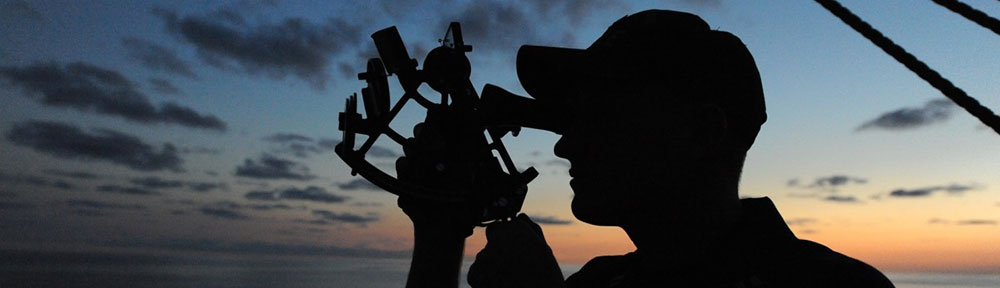
Challenge: Use the position of the sun as it dips below the horizon on the Autumnal Equinox (Sep 22, 2025) to define true West.
Under the appropriate heading in the comments below, post your best image along with a 1-¶ reflection: Did the sun appear to set before or after the official time of sunset? Why do you suppose that is? How might you improve data collection in preparation for documenting the Autumnal Equinox next week?
Under the appropriate heading in the comments below, post a 1-¶ reflection: how confident are you in these findings? How might you use landmarks in the photographs to improve the accuracy of your findings?
Under the appropriate heading in the comments below, post your best image along with a 1-¶ reflection: Did the sun appear to set due West? How can you tell?
Show/Hide due Week 2
Show/Hide due Week 3
Show/Hide due Week 4
Show/Hide due Week 5
Due Week 2
⤹Click the reply button just below.
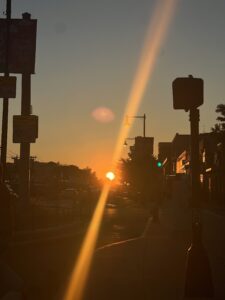
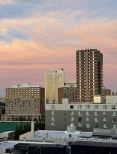
The sun had already begun to set when I took my photo near the Fenway bridge by Photonics. I had been walking around campus in search of an ideal spot, but many views were partially obstructed by buildings and trees. According to the forecast, sunset was expected at 7:05 PM, and I noticed the sun starting to set around 6:50 PM, which aligned fairly closely with that estimate. The early sunset appearance was likely due to the buildings blocking the direct line of sight to the horizon. For next week, I plan to photograph the sunset either from the Charles River Esplanade or from a rooftop location which would provide a much clearer and unobstructed view.
–
The sun started to set a little after the said time. I am sure the timing of sunset and sunrise is a little bit of guess work. When I was researching the time, I had multiple different answers; they were all close in time but varied about 5 minutes. I was unable to get a clear view of it due to my obstructed view. Once arriving to the location did I realize that it would be a good location for a sunrise not a sunset. I plan in the future to change locations to the Charles River where there is a more clear and defined space from the rest of Boston. In the future I would arrive about 20 minutes beforehand to have more time to explore the area and find the best place to take a photo.
–
I think the sun appeared to set before the ‘official time’. I was out 20 minutes before the sun was supposed to set and it appeared to be setting quick. I think it could have seemed to be that way because I did have obstructed view and it looked like it set faster than it was supposed to. I would improve the data collection before next week by finding a place with unobstructed view and from a view point where I can see the movement of the sun clearly. I would also make sure that I am closer to the western horizon.
–
This is, in my opinion, a great place to do the rest of the fieldwork. The location is at a friend’s apartment on Emmanuel’s campus. They live on the 18th floor so my view is relatively less obstructed compared to ground level. The sun set slightly before the official time of sunset, which I imagine is due to the small hill of buildings and greenery in my field of view. To improve my data collection, I may have to find a better location that has even less obstruction, this way I might be more aligned with the official time that the sun sets.
–
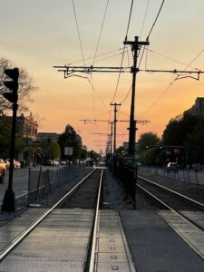
In the image uploaded, the sun has already begun to set. I took this photo on the train tracks around the center of campus. I believe it was setting before official time. With the surrounding buildings and the horizon line, the sun seemed to be setting earlier than what initially predicted. To further improve data for my collection, i could take numerous photos before and after the designated sunset time to better distinguish the difference between calculated and observed sunset expectations
–
My photo was taken at 7:15 on Sunday night, and it was a few minutes after sunset. The sun appeared to set pretty close to the time specified by web estimates, which could be due to my obstructed view. I took this from my friend’s dorm in Myles, so it was the best view I could get but obviously it’s hard to eliminate all obstacles. I could improve data collection for next week’s Autumnal Equinox by finding other potential locations for photography of the sun before the night comes. However, I do think this is a good location for the assignment and I would be glad to take the final pictures here.
–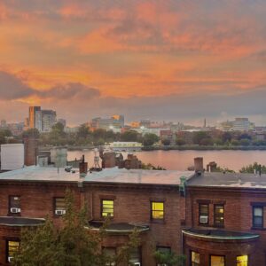
image:
:
It seemed to take a bit longer for the sun to set in this location than was predicted by my weather app. This was most likely because I was able to get up a hill and see it from a bit higher of a location. Because our perception of the horizon is dependent on our location, it makes sense that if you are higher up you may see the sun setting later than someone who is at a lower level.
However, for the next trial, I will be sure to get to a higher location because I wasn’t able to see the full effect of sunset. If I go to the top of the CDS building, where there is less obstruction, I should get a clearer view of the sun
–
The picture below was taken on the eighteenth floor of a building in Fenway at 1857, eight minutes before the official sunset time (1905) indicated on the iPhone weather app. Nonetheless, the sun appeared to set slightly before the official time. I suppose that the trees may have covered the view, causing a misinterpretation on my part, or the picture may have been taken from a higher horizon’s view. For the Autumnal Equinox, I may try to find a higher floor to take pictures from to avoid the trees (or any other obstruction) blocking the sun, or check multiple sources for the official sunset time beforehand as well.
–
When watching the sunset, the sun began setting well before the sunset time. I think that is the case since the time listed is when it is almost completely down. This angle was not the best due to not a full view of the horizon and trees blocking. For the Autumn Equinox, I will try to find a view of the full sunset with less obstructions.
–
This picture was taken on Sep 7th around 7:20. The estimated sunset time was around 7:05. The location where I took the sunset is from my apartment. The cloud on that day was too much so that the sun was blocked. The buildings in the direction that I took the image were short, so the view is actually clear, but maybe the view from the rooftop will be even better, in which case I can have a whole clear view, as there will not be any part of the apartment building blocking the sight.
–
The picture attached here was taken at 6:56pm on Monday (9/8) through my iPhone. This was a few minutes earlier than the official sunset time of 7:05 PM listed on the weather app. The “official” time is the moment when the very top edge of the sun disappears below the horizon, while from my viewing position, the sun seemed to be still in the process of going down. As I stood around Agganis Arena, the view was a bit obstructed by the buildings, tree, and students walking by, especially as the sun moved towards the horizon. The sun was also brighter than usual which made my camera harder to focus. For next week’s Autumnal Equinox, I would pick a spot with a clearer and more open view of the horizon and take photos every couple of minutes (both before and after sunset) to track the sunset more accurately.
–
I took this foto from the study area on the top floor of stuvi 1 on the left side of the building. The sun set was estimated to be around 7:15 but I was getting ready at 7:00 but the sun was obstructed by the clouds and if it went lower down it would make it very difficult to get a good picture of it. It seems that the predictions are not very accurate and you have to be ready for the sunset way before in order to get a decent picture of it. For the next trial run I plan to gown try again up here when the sky is more clear, or try down by the train station since there wont be any building on the trains path.
–
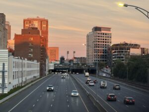
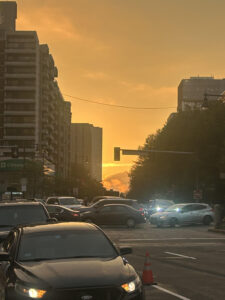
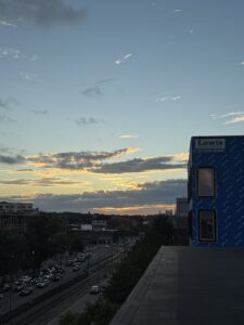
I took this photo at 7:03pm, and the sunset was at 7:06pm today. I took this from my car, and the location of this sunset is on intersection of the Fenway stadium. Although, I didn’t specifically get to see the sun setting, I got to see the skies change colors indicating the sunset. I tried getting a view from different angles, but didn’t succeed. Since, I didn’t specifically get to see the sun setting, I’m going to assume the skies changing as the sunset, and honestly it was fairly spot on. From my understanding, the sunsetting is just when the skies starting becoming a darker shade, and thats what happened. Although, I do realize that your location makes a significant difference in how the sunset may look for someone. For example, looking at our class most people have very differing images of the sunset, a lot of which were taken today of the same sunset. I believe improving data collection for documenting the Autumnal Equinox may require being in a location with low-rise buildings, and clear visibility. I think it may help to be at this 30 minutes before and after the indicated sunset time for that day.
–
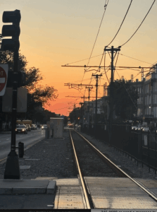
I was walking back from visiting a friend at another college and while walking back I noticed the dark sillohuette of the tree juxtaposed against the sunset sky. I noticed this around 7:10 pm which was close to my prediction from my weather app that said that the sun would set at 7:00. The sky is still for the most part blue but there is definitley a shift of colors as it gets pinker and then orange on the horizion. Even though the sun is not visible in this picture its clear that we can see where the sun is due to the brightness of the light.
–
This picture was captured at 7:03 pm, about 2 minutes before the official time of sunset. It appears that the sun has already set by this time, but that may be because my view was partially obstructed by buildings and the slight uphill in the road I was on. Because of the obstruction, I am unable to say for sure if the sun actually set before the official time or not. To improve my data collection, I might try to find a better spot that has a clearer view of the sun for the entire 15 minutes before the set time. This may help me discern better whether or not the sun set at that time or not.
.
–
The sun seemed to set after the official time of sunset. I think this is because I was in a high floor of a building. I was in my friend’s east-facing room, which I now realize was an error in picking locations. For the equinox I would find an optimal location that is unobstructed, at ground-level, flat and facing west. I’d also try to use the same time the official time is using to get in sync
–
The sun appeared to set around the exact time of the official sunset but maybe it set a little after. I suppose it seemed that way because the buildings obstructed my view of the sunset. I saw the glow of the sun after it set. I think the buildings made the sun appear to linger above the horizon longer. To improve data collection I think I should find a better spot to watch the sunset that is not so obstructed.
–
I took this photo around 3 minutes before the sunset time on the iPhone weather app. This photo was taken at my friend’s dorm on the ninth floor of West Towers in the towers dorm. Even though I was able to get a decent view of the sun almost setting, some of it was blocked by some buildings. I think for the Autumnal Equinox, I may try a higher floor in a nearby area, I was thinking maybe the upper floors of CDS, which will hopefully provide an unobstructed view
–
I took this photo on Sunday 9/7 at 6:52pm in Kenmore Square 15 minutes prior to sunset. Some other days I found the sun to be less bright even closer to the purported sunset time. Unfortunately, out of all of the photos I took on seperate days this was the one with the least amount of clouds. As you can see on the left, the Warren Towers block the sun. For the Autumnal Equinox I will try and get to the highest floor possible as I believe that will give me an uninterrupted view of the sunset.
–
I noticed that the sun started to set around 6:50 PM. I took this photo at 6:51 PM next to FitRec towards West Campus. My phone’s weather app, however, said the sunset would take place at around 7:05 PM. I then took a couple of more photos every 5 minutes until 7:10 PM. It seems that the sun appeared to set before the official time of sunset. From this, I think that the official time of the sunset is not the time it starts setting but rather the time where the sun is completely set, meaning it is no longer visible and the last visible part of the sun disappears below horizon. To improve this experiment, I would go somewhere with less obstacles like buildings for a clearer view of the sun.
I am not sure why the picture did not upload but here it is
–
I noticed that the sun started to set around 6:50 PM. I took this photo at 6:51 PM next to FitRec towards West Campus. My phone’s weather app, however, said the sunset would take place at around 7:05 PM. I then took a couple of more photos every 5 minutes until 7:10 PM. It seems that the sun appeared to set before the official time of sunset. From this, I think that the official time of the sunset is not the time it starts setting but rather the time where the sun is completely set, meaning it is no longer visible and the last visible part of the sun disappears below horizon. To improve this experiment, I would go somewhere with less obstacles like buildings for a clearer view of the sun
–
This picture was taken at around 18:55, which was very close to the approximated time of 19:05 that the Weather App indicated. The sun was however already partially covered by the horizon, which could be caused by the uneven terrain. Therefore to avoid this, the ideal location to take the picture would be on a rooftop, with a clear view of the horizon and ideally a clear sky.
–
To be completely fair, I did not notice the exact time of sunset as I just made sure to go outside when the sun seemed to be setting. But if I had to make an assumption I would assume that it would set a few minutes after the allotted time in the weather app because I was near Agganis which is higher than sea level compared to other parts of Boston. I also think that I can take a better picture next week from a higher point with a more clear view with less buildings and objects to obstruct the view.
–
This is the picture of the setting that I took on September 7th at 7:08pm from my apartment. I tried to find the easiest accessible, highest location that I could find. I had a good view of the sky, but unfortunately, I actually missed catching the sunset because it was set behind the white building in front of me! I guess it wasn’t a bad idea to do this practice run, since I now know that I probably need to find a better location where the sunset isn’t blocked – maybe a higher point or a location that isn’t blocked by the direction of the sunset.
–
I took this photo at about 7:08 PM right across BU Fitrec. From my perspective, it looked like the sun dipped below the horizon a little earlier than expected, probably because nearby buildings and trees blocked my view before the sun was technically down. Since the official sunset is measured at an open horizon, my observation felt slightly ahead of schedule. To improve data collection for the equinox, I would choose a spot with fewer obstructions, maybe on higher ground, and begin taking photos earlier so I can better capture the full transition of the sun setting.
–
On September 8, 2025, I observed the sunset from the balcony of my apartment on the 8th floor in Brookline. Being higher up gave me a broader vantage point than street level, but I still found that the city skyline partially blocked my line of sight to the western horizon. The official forecast listed sunset at 7:05 PM, yet from my perspective the sun appeared to dip below the buildings several minutes earlier. This reinforced for me how local geography and elevation can shift the actual viewing experience of sunset times. For future observations, I plan to compare my balcony view with a more open location like the Charles River or an elevated rooftop where the horizon is less obstructed, allowing me to track the sun’s movement more precisely against the official times.
– IMG_0913.pdf
This photo was taken from my friend’s dorm in Danielson, just a few minutes after sunset, looking toward the Prudential Center. The sun was partially blocked by the tall buildings on the horizon. For the Autumn Equinox, I’ll probably head to one of the higher levels at CDS to get an unobstructed view.
–
I captured this sunset from the balcony of my apartment while facing east, which meant I could only observe the sunset indirectly through the golden reflections on the windows of the tall buildings across from me. The sun had already begun to set when I took my photo at 7:08 PM, appearing to disappear before the official sunset time of around 7:19 PM for that date. This early disappearance left me wondering how exactly the official sunset time is determined – whether it accounts for geographical obstructions or is calculated based on a theoretical flat horizon. My eastward-facing perspective presented unique challenges, as I was essentially documenting the sunset’s afterglow rather than the sun itself. For the Autumnal Equinox documentation next week, I plan to relocate to a position with a direct western view, perhaps from a rooftop or an open area where I can observe the actual sun rather than its reflection. I would also arrive earlier to better understand the relationship between the predicted sunset time and what I can actually observe from my chosen vantage point.
–
I took this picture on a bridge accessed from Bay State. This location provides a clear western view, which is essential for tracking the sun’s movement. The elevated pedestrian bridge gives an unobstructed sightline over the traffic and rooftops, allowing the sun’s position relative to the horizon and nearby landmarks to be observed and recorded accurately. Although nearby buildings partially frame the horizon, the wide angle and open sky make it a strong candidate for conducting the full experiment.
–
The sun started to set a little before the time on my weather app. It said about 7:05 and this pic was taken at 6:43pm. I think this might be because Brighton and Newton are pretty hilly and have taller trees which blocks the horizon and gives the illusion of the sun setting earlier. My view was a little obstructed by clouds but I’m confident that the level I’m taking the picture at can get a good view without any buildings blocking it. During the Equinox, I intend to take pictures on both Sunday and Monday just in case it’s cloudy on one of the days.
–
Due Week 3
⤹Click the reply button just below.
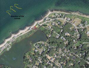
I am pretty sure of my findings as the sun’s direction of setting is west and I was able to mark that on my map. However, the exact position that I took the photo from might vary depending how well I aligned my photo with the map. The landmark which I referenced with this photo is the Fenway T-Stop. I take this route almost every day because I live in the area and that makes me more confident in regards to the position I took the photo from. In the picture, we can also see the Time Out market building very slightly on the left hand corner which also helps me be more accurate with the markings I made on the map.
– Screenshot-2025-09-15-at-11.48.40-AM.pdf
I am confident in my map drawing as the sun is known to always set in the west, and in my photograph the sunset aligns directly down Com Ave, which runs in an east–west direction. The map shows my location on the street next to the Boston University Bridge. I could use landmarks like street signs, buildings, or banners in the photo to pinpoint my exact location and confirm the direction of the sunset more accurately.
.
–
I am confident about my findings, as my picture faces west from the Fenway Bridge near Photonics, and the sun sets in the west. The landmark I used is the BU Department of Electrical and Computer Engineering. When taking the photo, I noticed some buildings partially blocking the view, which affected how clearly I could see the sun’s position. To improve accuracy next time, I plan to use more open spaces with smaller landmarks, rather than buildings.
– Map.pdf
I took the pictures of the sunset on September 14th from my apartment again. I am quite confident in my placement of my viewing position and the direction of the sunset, as we know that sunsets occur in the west, and I confirmed my direction by facing west before taking the pictures. To improve the accuracy of the data in the future, I may identify nearby buildings, allowing me to locate my position more precisely on the map. Also, next time I should try to go to the common area on the rooftop, so that I can avoid the part of the apartment building and the faraway buildings blocking some part of the views.
image of the map:
–
I was able to access my rooftop to take this picture, even if it was not as high as it would ideally be, it still was much clearer than the past pictures I was able to take. The sun is clearly seen setting in the West and there are some buildings that can be used to improve the accuracy of my findings. However, due to the uneven terrain, there are also some hills that block the sunset, which may complicate the task.
Photo 1
.
Even though I couldn’t capture a good picture of the sunset I still watched the sun drop so I could kind of guess the direction of the sun. Actually I used the building it dropped behind as the main landmark which turned out to be fairly useful. By checking on google maps and drawing a line from my direction to the building that the sun dropped behind, I could get a general direction of the sunset. The map shows that the sunset mostly to the west and slightly to the north and this makes sense because we should expect the sun to be perfectly west during the equinox which is coming soon. One way to improve landmarks used is to find landmarks further away because this means the line between me and the landmark could be longer which would result in a more accurate angle of the sun. Surprisingly even though I couldn’t see the sunset directly, I felt like this was still pretty accurate because I could catch where the sun was falling.
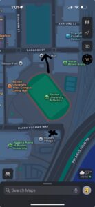
I am very confident in my ability of taking a photo that was good. On the way to class on Friday, I was taking the Babcock T-stop when I decided to use the compass app on my phone and pointed down the street towards Packard’s Corner. When I checked the compass app, the angle was 260 degrees which is near almost perfect west (270). Using the Babcock T-Stop was helpful as it helped me get a straight shot without any issues of uphill. The only thing I would change is maybe going further down Beacon Street since there is a building that goes between Commonwealth and Beacon.
–
Here I have attached the map where the map has been manipulated to show where I stand and has been rotated to have West at the top of the compass as dictated on the photo.
–
I am not as confident as others in my findings. Of course, the sun was setting in the west in my photo, but the location that I decided to take the photo at had my view of the sun actually setting blocked heavily by a building. I am unsure if it was the building itself blocking the sun or the sun setting much earlier than stated online. The landmark location is the Boston University Bridge, near the beginning of the arch.
– Week-3-Cosmic-Visions-Fieldwork.pdf
I am confident that I correctly marked the position of the setting sun and my own location. If I am on Comm Ave, I know that the sun sets in the west, so I would need to look towards the direction of West Campus. Landmarks on West Campus include Stuvi 1 & 2 and Agganis Arena. My location is on the south end of the BU bridge, which I know because the Charles River is north of BU’s campus. I also know that the Green Line B branch runs west to east and vice versa so I can also orient myself with the T. Using all of these landmarks can help improve and confirm the direction of the setting sun.
–
I’m confident in my findings as the direction of the sunset is west and it was marked on the map. The landmark referenced in the map is Warren Towers. I was in my friend’s room around sunset a lot last year, so I was very confident that I was facing the correct direction for sunset. Landmarks include the BU Bridge, the Photonics building, and the StuVi buildings
–
I am not too confident about my findings as I was not able to directly see the sun. The buildings I used as landmarks were Warren towers, CDS & the Kenmore tower. I estimated the position of the sun based on how much of the Kenmore tower & Warren towers was visible in the picture and then guessed by a degree or two. For the equinox I intend to go to CDS, so these landmarks now won’t be relevant.
–
I took this photo on Sunday at 7:13pm, the sunset at 6:53. I took this photo on Martha’s Vineyard, right by the East Chop Lighthouse, which is supposed to be the best sun set view on the entire island and it was very beautiful. I believe the direction of the sunsetting was northwest, though I was slightly late and missed the sunsetting, I was able to see the horizon and tell the direction. I’m somewhat confident in these findings, I understand the sun sets westwards, but I wasn’t necessarily exactly facing westwards, and more northwest. Maybe if I saw the actual sunsetting I could be more accurate about the direction. There weren’t many landmarks around my location, other than the East Chop lighthouse. I do believe being in a location with less landmarks/buildings could be very helpful with getting an accurate view.
–
Map:
–
Though landmarks in the west are not quite visible in the attached picture, I am quite confident in my findings. This is because I ensured to prop up my phone straight up against the window on the righthand side of the utmost corner of the eighteen floor towards the sunset in the west. However, I can use the bumpy tree and sky line to draw, compare, and improve the accuracy of my findings, as Prof. Henebry did in class from his sunset pictures in Sicily. I think it would be interesting to take another picture nearer to the Autumnal Equinox in the same way and compare the two, or find other notable buildings or intersections in the view, such as Park Drive and Riverway, to further my confidence.
–
I took a photograph from the 26th floor of Stuvi 2 at 6:52 on Monday, September 15th for my reference. I made sure to include the shape of the soccer field below, and I noticed that the top right corner of the field nearest to Rich Hall pointed pretty directly to the sunset. From this information I approximated an angle of the sunset and I think that my findings are pretty accurate. I think I could use other buildings in the future next time that are further out to make further references, but I think I made good use of landmarks given my resources.
My map
Map
–
Sunset
–
To add to this, the angle of the sunset was moving southeast. the angle was not very steep as the movement between pictures was mininal, but there was definitely a slight eastward movement of the sun as it set southward.
I am very confident with these findings. I took the pictures maybe 10 minutes in between and the sun follows a path corresponding to the angle (latitude) that we are in. Now I know that in that specific spot, the sun set will always be covered by the building seen in the picture. For the pictures before, it was easy to take it from the same location due to the buildings presence and how far away the sun was from that building. I also took the pictures while leaning up against a wall so that it was taking from the same reference point. I will have to choose another place to take the pictures from, but I can use the buildings/ landscape in order to line up the pictures so that the process of analyzing the sun’s path is more clear and accurate.
–
I am confident about the location of the sunset because I watched where the sun goes down and used it to mark west on the map myself. Since the sun always sets in the west, seeing it sink toward the horizon gave me a reliable natural reference. By matching that observation with my position along the Charles River, I could draw the “West” label knowing it was based on an actual sunset direction, not just a guess.
–
I am pretty sure of where I think the sun was setting that day, but my positioning may vary. The landmark I referenced for this was the CDS building, which was blocking my full view of the sunset. Another building I referenced was the Wheelock School of Education, which was directly in front of of me when I took the picture. Next time, I may try to get higher, and maybe try another building like CDS or Photonics.
–
I am confident about these findings because they seem to follow the patterns of sunset we have talked about in class. As I took pictures, I noticed that the sun was setting at an angle as well. I was able to use the flags on top of the Howard Thurman center to help me see this. Landmarks help us figure out the exact positioning of the sun’s setting in comparison to our own.
Here’s the image
–
I’m fairly confident in my findings since I noted both the time and general direction of the sun as it set. My position near Agganis Arena gave me a quite good sense of direction, though the buildings and trees partially blocked my view. If I used recognizable landmarks in the photographs like the outline of Agganis Arena itself, streetlights, or the T stop, I could align those with the map to mark the sun’s position more precisely. Next time, I’d also consider using a compass app or the map’s grid lines alongside my photo to confirm the direction of the sunset. Moreover, I would stand at a higher point of view to observe the scene more accurately and easily.
Map:
– Sunset-view-point.pdf
I am confident in my findings because I was able to mark where I had taken a picture yesterday at the GSU on the map. On the map where I took the picture you can see the direction of true west runs parallel to the angle in which I had taken the picture. But to be more accurate I think it is worthwhile to observe more and see throughout multiple days and use more landmarks to determine the true direction.
–
This time around, I was able to get a clear-cut view of the sunset. Every time I am at the 26th floor of Stuvi 2, I notice that the sun sets from the west side of campus. Thus, I went back to the 26th floor to reaffirm this. While the three west campus buildings may slightly obscure the view. Stuvi 2 is considerably higher than them (at least 13 floors higher). Thus, I was able to get a beautiful view of the sunset. I am absolutely confident that this is the best place on campus to get the clearest view of the sunset.
–
I am fairly confident in my picture and my map drawing. As can be seen in the photograph, I was able to capture the sun pretty clearly and you can see the T-stop, street signs, the intersecting street, and other landmarks to identify the location I took this photo and confirm the direction.
–
Map drawing
I don’t know why it did not attach my picture. Here is my drawing:
Apologies, the wifi is really slow. Map drawing:
I was facing west – north west, I am pretty confident that my findings face towards the west, as I was facing towards the Charles, and towards west campus which is always a good way for me to know if I am facing west or not. I could use the buildings in the background to better position myself, as well as landmarks near by such as the Parkman Bandstand which was exactly to my right, also facing west. Although it would have been beneficial to take the image without the tree obstructing the view, it was the clearest picture I could take at the time.
–
Map
As you can see in the photo, the compass is pointed toward the west, which matches the fact that the sun is setting directly in that direction. I am confident in these findings because the sun sets in the same spot every evening, and our balcony faces that way. Using landmarks visible in the photograph, such as the outline of nearby buildings or the horizon line, could further confirm the sun’s position and help improve the accuracy of the map marking.
– IMG_8CF91E253BD4-1-1.pdf
I feel fairly confident in these findings because the train tracks provided a clear directional guide. Since the tracks themselves run west, and the sun was setting directly in front of me along them. However, the horizon line was not completely clear and the sun was not completely visible due to the horizon line being blocked by several buildings, since I took this photo on ground level. To make my mapping even more accurate, I need to find a way to gain elevation to gather ideal images as well as write down nearby landmarks to cross-check my exact position and confirm the perspective of the shot. These extra details would significantly improve my findings
–
I am pretty confident in my findings. I took this photo on July 23rd, 2025, in Greece. This would further support the fact that the sun would be setting in the south-western direction. I attempted to line up the sunset with the island visible in the photo, which I found out is likely Zakinthos.
–
Original photo
–
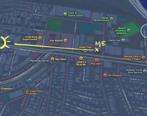
Im confident in my markings on my map since the window outside my room points west. I’m able to reach the rooftop of the building so I can see the sunsetting fairly well with no obstructions. My landmark would be the edge of Star Market. I lived in this building last year and would watch the sun set quite a bit so I’ve noticed that in September the sun sets closer to star market and throughout October and November it starts to shift and set across the street above the Packards Corner T stop.
–
When observing the sun setting, I used the tower above time out market as my landmark. From my apartment, and factoring in my angle of view, the sun sets almost directly behind this building. When I checked on the map and with my compass, my view of this building is almost exactly due West. Due to my angle, even though the building is due west from me, I am able to see the final setting of the sun on the side of the tower. With this, I am confident in my findings as my positioning and angle allows me to view the sunset.
Attached is the photo
ving the sun setting, I used the tower above time out market as my landmark. From my apartment, and factoring in my angle of view, the sun sets almost directly behind this building. When I checked on the map and with my compass, my view of this building is almost exactly due West. Due to my angle, even though the building is due west from me, I am able to see the final setting of the sun on the side of the tower. With this, I am confident in my findings as my positioning and angle allows me to view the sunset.
Due Week 4
⤹Click the reply button just below.
Im confident in my markings on my map since the window outside my room points west. I’m able to reach the rooftop of the building so I can see the sunsetting fairly well with no obstructions. My landmark would be the edge of Star Market. I lived in this building last year and would watch the sun set quite a bit so I’ve noticed that in September the sun sets closer to star market and throughout October and November it starts to shift and set across the street above the Packards Corner T stop.
–
The sun appeared to be setting in the west because the area from where I have taken the picture from faces the west side of campus and in the picture too, we can tell that the sun is approaching the western horizon.
– IMG_6796.HEIC.pdf
I was able to get a nice photo of the sun setting at 6:36PM on 09-22-25. I took my photo from the Hiebert Lounge in the L-BLDG on the medical campus. I was able to distinguish my location from a building with a unique design the the right of the sun setting, by using google earth I was able to find that building estimate where the sun is based off the photo. From google earth I was also able to position the compass to point directly north, and when I drew my line towards the sun from my POV it pointed perfectly West, which is how I know it set due West.
–
I took my photo from Floor 26 of Student Village II on BU campus. I began photographing 40 minutes before sunset around 6 pm and took pictures as it progressed toward the horizon. I noticed personally that it was not setting due west. My primary theory is that I was not positioned underneath the setting path of the sun, so when it traversed through the sky, my angle of observation made the path seem diagonal. However, I sat in the same position to record last week’s data, and the angle of descent is definitively less steep, so I believe the course of the Sun definitely was more vertical and could have been setting due West, however my position in proximity to the path could skew my analysis.
–
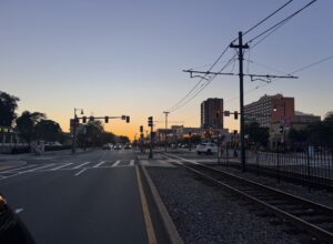
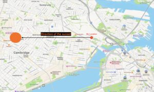
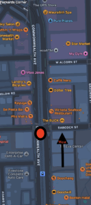
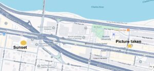
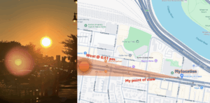
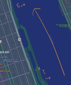
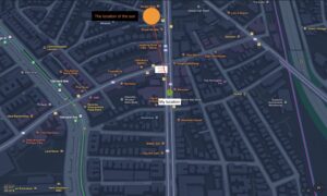
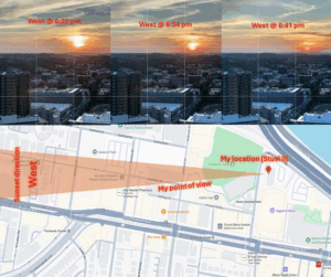
On September 22nd, I ran into some sudden logistical issues and could not enter a tall building to record the sunset. However, I was able to run over to one place, the bridge over the Green Line’s Fenway Station (noted in the attached screenshot), where I could see the sun setting perfectly in the middle of my view between some buildings. With the landmarks in the picture, I was able to make out a line of sight on the satellite version of the map. The arrow’s head, noting the sun’s location, points just to the right of the tall building shown to the left of the sun in the photograph. Additionally, the arrow goes straight to the left of where I was standing, so the mapping proves that the sun set due West. Though initially frantic due to the unexpected issue, I am thankful that this one location provided the perfect opportunity to take the sunset picture with landmarks, facing exactly to the West.
–
I took this picture at 6:37pm on the 21st a couple minutes before the “official” sunset time from my rooftop. I got a good view of the sun setting in due west from my location by directing my map’s compass west. I confirmed this was due west later when I drew a line directly westward on my maps and it lined up correctly in relation to the billboard on top of the building on the left.
–
I took this picture on September 22, 2025 at 6:38pm, and the sun was supposed to set at 6:41pm today. I initially went out onto Commonwealth Avenue, right in front of the GSU, but wasn’t really able to capture the sun, due to the angle and obstructions. The photo that I’ve attached was taken in the BU law building, on the 17th floor, facing westward towards BU west campus and Boston College. As visible in the picture, the sun is towards the left and is almost dipping under the horizon. The weather app also indicated that it was slightly cloudy, so that could be why the sun isn’t the clearest. I believe my picture accurately shows the sunset westwards, as indicated by the surrounding buildings.
photo
–
map
–
Yes, the sun appeared to be setting in the west. I can tell, as I took the photo at 6:31pm from the 9th floor West Study Lounge in the Photonics building. This was further confirmed upon using the compass app, which showed due west when pointed to the setting sun.
–
I took this photo at 6:39, about two minutes before the official sunset. In this photo, you can clearly see the sun setting in the west. I was near Copley square on the dock. I chose this location due to do its clear, level view of the western horizon. The sun did get slightly hidden slightly after the “official” sunset time due to the cloud. Due to that I opted for a photo of the sun beforehand. When the sun was coming down, it did look like it came down towards the right of my screen, especially after taking another look at the photo I had taken. I will attach my location as a reply to this one.
–
Here is my location:
–
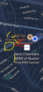
I took this photo in Allston today, about 10 minutes before sunset, around 6:30. I was out for dinner this evening, but I couldn’t find a place high enough to take a clear image of the setting sun. However, I have recorded the position of the sun. The picture of the sunset was shot on Brighton Avenue, and I’m pretty confident the sun was setting in the west. The reason is that the street runs parallel to where I was standing, and I remember the sun dipping off to the left rather than straight down the street. Plus, I noticed the CITGO logo located exactly in the direction of the sunset, and when I lined the two up, it clearly pointed toward the west, confirming that’s the direction the sun was setting.
–
map
–
I took this photo on Stuvi II’s 26th floor today, about 3 minutes before the sunset time indicated on my phone. The sun is visible and is dipping below the horizon. I’m confident in my findings because in this photo, you can clearly see the sun setting below the horizon, along with the West dorms and Nickerson Field in front of it
sunset image
–
my location
I took this picture on Brighton Ave by the Packard’s Corner Green Line stop around 6:45. It was hard finding enough open space on the sidewalk to take the picture as there were trees blocking the way even though the street was wide open. Brighton Ave faces slightly northwest so the sun set on the left side of the picture. Due to time issues I wasn’t able to find a less obstructed view.
–
Taking my picture from outside of Little Tao’s since I was eating there around 6:40 pm, when the sun should have been setting, I wasn’t really able to get a clear shot view of the sunset, but could assume it was almost setting due west from the area where the remaining sunlight was emanating from. Will try to take a clearer picture from a better spot, though, later tonight.
–
During the late summer Boston’s position in the Northern Hemisphere means the sunset gradually moves southward along the horizon each day. IN September 22, the Earth’s tilt is neutral relative to the sun. This means the sun will set almost perfectly due west. It allows us to find a true west reference point in your local landscape. Following this day, the sun continues its path southward, causing the sunset to occur progressively farther south along the horizon each day. The amount of daylight available in Boston decreases at its fastest rate of the year, with a noticeable difference in daylight duration just a few days after the equinox.
–
On September 22nd, I went to the 26th floor of Student Village II in West Campus to get a clearer view of the sunset. I took my pictures over a span of 25 minutes until sunset. There are multiple visible landmarks in the snapshots such as Sleeper and Rich Hall, as well as Star Market and Malvern Field, allowing us to clearly identify the location of where these photos were taken. I also used the Rule of Third grid to show the Sun moving down over time. We can see that over time, even though the equinox is set due west, our ~42 N degree latitude (Boston) makes the Sun slide diagonally down from our perspective.
–
This picture was taken at 6:35 pm on Sep 23. I used the same spot as I did for my first sunset picture, right by the BU bridge. The sun appeared to set due west in a similar spot to my fieldwork picture from 2 weeks ago. This time it did appear to shift a little to the left. I can tell its still to the west based on where I am standing and looking. (com ave runs east to west)
–
I am confident on where true west is. This photo was taken around 6:50 yesterday on the day of the equinox. I took this picture from the top of the Student Village 2 lounge and it had lined up with my other observations of the sunset. I was able to line up the sunset trajectories with the map and I realized where true west was. I also attached the picture because I think it is a great picture.
–
Thank you to some other submissions that helped me see that there was a compass on Apple Maps. I just used this compass to create a line going due west (I used an editing tool to move it from the compass to my point of view). The sun was between the BU law school and the innovation center. The sun seemed to be closer to the innovation center in my picture and farther from law school, which would position it in the west.
Image
–
map
–
I took this photo due to a cloud block my view, so I cannot catch the first picture. On the autumn equinox, the Sun goes down almost straight toward the exact west horizon, with no lean to the north or south; after it disappears. I guess the next days it will start setting a little farther to the southwest each evening.
–
I captured a series of sunset between 18:27 and 18:37 on September 22, 2025, from the 15th floor of Boston University’s College of Computing & Data Sciences. The sun was observed setting directly along Commonwealth Avenue, and the compass reading confirmed an azimuth of 270° W, aligning with true west. This matches the expected solar position on the Autumnal Equinox, when the sun sets due west globally. The images, map location, and compass reading together clearly demonstrate the sun’s alignment with true west on this day.
–
I took a photo of the sun at 6:37 pm on the 26th floor of Student Village II. From this view, I was able to get a view of the sun starting to dip below the west horizon right ahead of Rich Hall in west campus. My perception of the position of the sun was slightly skewed due to the cloudy skies. Moving forward, I will take a picture closer to 7:00 pm to examine the position of the sun relative to the horizon and whether it’s still visible at that point.
–
I observed the sunset from the 26th floor of Student Village 2, located at approximately 42° 21′ 11.76″ N, 71° 7′ 4.12″ W. This side of the building faces west toward Allston and Brighton, giving a wider and clearer view compared to my first attempt on week 2. On the Autumnal Equinox, the sun rises due east and sets due west because its path lies along the celestial equator. In a compilation of photos I took below (captured from 6:20 – 6:39pm), the sun is above the horizon line straight ahead (except for the last picture where it disappeared), confirming that my position was aligned westward. Astronomical data for Boston on September 22, 2025, places the sunset azimuth at around 271°, which is essentially due west (270°). The photos further show that the sun set almost exactly due west on the equinox. My observations match this data, showing that the sun set almost exactly due west on the equinox.
GML Web Team. 2025. “Solar Calculator – NOAA Global Monitoring Laboratory.” Noaa.gov. 2025. https://gml.noaa.gov/grad/solc.....;year=2025.
McClure, Bruce. 2025. “The Equinox Sun Rises Due East and Sets Due West.” EarthSky. September 17, 2025. https://earthsky.org/tonight/e.....-due-west/.
– Sunset-process.pdf
A picture of the map that shows my position and sunset view.
– Map-1.pdf
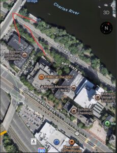
On the autumnal equinox, I watched the sun dip below the horizon from the CDS building at a nicely elevated position. Indeed, looking at my phone compass, I believe that it set almost exaclty due west. Fairly symmetrical, which reflects how the authumnal equinal nicely balances day and night, in which the path of the Sun is aligned with the Earth’s equator. In retrsopect, it was truly a nice sight to watch this, as it reminded me that the motions of the heavens are measurable and ordered.
–
This time I was able to access a rooftop and photograph the sunset with a somewhat clear point of reference. Unfortunately there are no tall building or landmarks that I can use to compare the sunset, but similarly to what we did in class, I used the horizon and its relief to be able to compare it with previous sunsets. I used the trees, in particular the tallest one as reference. From there I was able to tell the Sun was setting on the West at an angle. From now on, since I have secured a spot with an elevated and somewhat clear view, I will compare the pictures and see more clearly where the Sun is setting.
–
My location
–
The Sun did appear to set due west. Now That I have looked at my map, I see that it did indeed set due west. I can tell by the angle that I took my photograph at facing from my location and then checking that against the map, and seeing that it faces exactly west. I went up to the 5th floor of the CDS buidling on the BU campus in order to take this picture which, the street and building there, is slightly off of facing exactly due west.
– Cosmic-Vision-Fieldwork.pdf
This is my photo of the setting sun during the Autumn Equinox, taken on 6:50pm from my apartment. I went to the top of the building this time. Knowing that the sun would be blocked (from previous experiences), I took a photo before the sun dropped below the building, instead of waiting for the real sunset – the direction is most important, and it shouldn’t make a difference if I capture it at the exact time of sunset. From my perspective, the sun appears to drop right behind the building shown below. Going on Google Map, I can draw a straight line from my location to the location of the sunset, which is mostly due West.
I took my photo at the same location right off the BU bridge on Comm Ave where I took my picture the previous week. This photo was taken about 8 minutes before the actual sunset time becasue the sun was already dipping below the buildings. The sun appeared to have set due west, because it was shifted a little furhter to my left compared to 2 weeks ago. The green line runs east to west with a slight northern tilt at that part of Comm ave. Because of this, it would make sense that the sun appears to have shifted to my left facing westward.
–
The sun appeared to be setting west, but just to be sure I used a compass to check if it was accurate and I found that it wasn’t setting exactly due west but a little to the north west, but that could be due to compass malfunction or my hand not facing the sun exactly. I took this image from the top of my apartment building in Allston, to the right you can see a large building within that building lies the Brighton Islamic Center which was north west of me, so it was fair to assume that it was setting near due west.
Sunset
map
sunset
–
Compass
–
map
–
The sun appeared to be setting west, but just to be sure I used a compass to check if it was accurate and I found that it wasn’t setting exactly due west but a little to the north west, but that could be due to compass malfunction or my hand not facing the sun exactly. I took this image from the top of my apartment building in Allston, to the right you can see a large building within that building lies the Brighton Islamic Center which was north west of me, so it was fair to assume that it was setting near due west.
Sunset
map
I took the photo roughly 10 minutes before the reported sunset. Unfortunately the day was a little overcast so I couldn’t see the sun perfectly. I believe that the sun actually did set in the west as the line I drew is close enough to perfect perpendicular that the margin of error is negligible. The square I drew on the map is the law building being used as a landmark. Unfortunately there were no landmarks to my left as that could have helped me get a better estimation of where the sun set.
–
The Photo was taken on the 10th floor of CDS
During this documentation, the sun was positioned slightly behind the building I used as a landmark, but from my perspective seemed to not be exactly due west. Maybe do to my angle being not direct, the sun seemed to be on the right of the building slightly before completely setting and behind another smaller before losing sight on the horizon. With this it seemed to not be exactly 273 degrees, but maybe a degree or two off. The black dot represents the building and the red dot the sun slightly before setting when I observed.
Attached is the photo
During this documentation, the sun was positioned slightly behind the building I used as a landmark, but from my perspective seemed to not be exactly due west. Maybe do to my angle being not direct, the sun seemed to be on the right of the building slightly before completely setting and behind another smaller before losing sight on the horizon. With this it seemed to not be exactly 273 degrees, but maybe a degree or two off. The black dot represents the building and the red dot the sun slightly before setting when I observed it.
Due Week 5
⤹Click the reply button just below.
Attached below is the PDF of my final version.
– Field-Work-Final-Paper.pdf
Fieldwork Final Paper – Week 5
– Fieldwork-Final-Paper-Week-5-1.pdf
Final Version pdf
– IN250-Autumnal-Equinox-Paper.pdf
Fieldwork Final Paper:
– Field-Work-Final-Paper.pdf.pdf
IN250 Finalized Autumnal Equinox Fieldwork
– IN250-Fieldwork-Final.pdf
Final version of the fieldwork.
– Autumnal-Equinox-fieldwork.pdf
Autumnal Equinox Fieldwork Paper
– IN250-Equinox-Fieldwork.pdf
Attached below is my Autumnal Equinox Final Fieldwork paper.
– Chaahat-Walia-Autumn-Equinox-Fieldwork-Final-paper.pdf
Fieldwork attached.
– Autumnal-Equinox-Fieldwork.-Kate.pdf
Field work final paper – week 5
– Field-Work-Final-Paper-Nguyen-Le.pdf
Attached below is my fieldwork paper.
– Doris-Guo-Autumnal-Equinox-Fieldwork-Paper.pdf
Final PDF Version
– Autumn-Equinox-Final-Project.pdf
final:
– Autumnal-Equinox-Final-Version.pdf
below is my document
– Equinox-Report.pdf
Attached PDF of fieldwork:
– Autumnal-Equinox-Write-up-John-Adams-.pdf
below is my report
– Autumnal-Equinox-Fieldwork-Report.pdf
Fieldwork paper – week 5
– IN250-Autumnal-Equinox-fieldwork.pdf
Equinox Final
– Autumnal-Equinox-Final.pdf
Fieldwork Final Paper:
– Autumnal-Equinox-Fieldwork-Essay.pdf
Autumnal Equinox Report:
– IN250-Autumnal-Equinox-Fieldwork-Juan-D.pdf
Final PDF Version
– Equinox-final.pdf
Autumn Equinox Week 5
– Autumn-Equinox.pdf
Field Work Paper
– Autumnal-Equinox-Fieldwork-Report-Xiao-Nie.pdf
Autumnal Equinox Final Write Up
– Autumnal-Equinox_Final_Write-Up-.pdf
Fieldwork Final Paper
– Lingjun-Kong_Autumn-Equinox-Fieldwork-Final-Paper.pdf
Final paper week 5 Ryan Hayashi
– Ryan_Hayashi_Autumnal-Equinox-.pdf
Fieldwork Final Paper – Week 5
– Autumn-Equinox-Paper-Samuel-Jimenez-Silva.pdf
IN250 Autumnal Equinox Report 2025
– IN250_Autumnal-Equinox-Report.pdf
Final paper
– Omar-Tawfik-Autumnal-Equinox.pdf
Attached below is the PDF of my final version.
– WEEK-5-AUTUMNAL-EQUINOX-SUBMISSION.pdf
Standing at a clear spot with an open view of the western horizon, I watched the sun sink slowly on the evening of the Autumnal Equinox. The sun appeared to set almost exactly due West, which I could tell by lining it up with a nearby street that runs on an east–west axis and noticing how directly the sun hovered over that path as it touched the horizon. The alignment reinforced what we learn about the equinox, that it is the one time of year when the sun sets precisely in the West, marking the balance between day and night.
– IMG_1050.pdf
Interesting read! It’s cool how gaming is evolving, especially with mobile apps. Heard the bingoplus app app is gaining traction in the Philippines – quick installs & localized payments seem key! Definitely a new way to play.
Solid article! Thinking about bankroll management & VIP experiences, bourg basketball offers quick verification – a huge plus for serious players. Prioritizing smooth deposits is key to staying focused!
Just a busy parent here needing quick wins; this PAGCOR-licensed site on arena plus login com offers safe, legal gaming for Filipinos aged 21+, perfect for my short breaks.
It’s fascinating how platforms like jl boss login are prioritizing seamless onboarding & security – crucial for building trust. The focus on local payment options like GCash really enhances the user experience, too! 🤔
Just found this while studying stats! The local payment options like GCash are huge for PH players. Finally checked out the OKBet Register apk on my phone, looks legit with 24/7 support too.
Just finished my weekend research on Filipino casinos and found this gem. The secure login and diverse games at gbets vip look perfect for serious players seeking top-tier entertainment right now.